Land Creates Water
Decentralised Water Retention – Visions and Fields of Action
Contents
• Introduction
• 1. Capturing and directing water
• 2. Slowing and spreading runoff
• 3. Bringing water into the soil
• 4. Building soil as a reservoir
• 5. Developing vegetation as water infrastructure
• 6. Strengthening animals and fungi as co-creators
• 7. Creating open reservoirs and wet landscapes
• 8. Cleaning, using and circulating water
• 9. Securing planning, maintenance and observation
• State of the approach / professional context
• Sources and literature
This summary combines a basic understanding, a logic of measures and practical orientation. It is intended, on the one hand, for people who work practically with landscape, soil, water and land use and are looking for ways to improve the water balance of a place. On the other hand, it is also intended for people who care about the well-being of their wider living environment and would like to develop a better understanding of the ecological relationships between nature and culture.
The following chapters build on one another, but can also be read individually. Together, they do not describe a rigid catalogue, but a framework for action that can be adapted to very different places and starting conditions.
Introduction
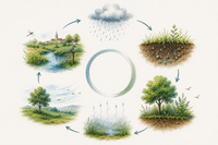
Water is the foundation of living landscapes
Where rainwater can be retained in the soil, in vegetation, in wetland structures and in decentralised storage areas, landscapes become more robust, cooler, more fertile and ecologically richer.
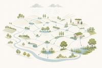
Decentralised water retention is an integrated form of future-oriented landscape development, not an isolated technical task. Water is understood as a shaping resource, not as a surplus that has to be drained away.
Water, soil, vegetation, animals, fungi, land use and spatial design are considered together as parts of one connected system.
The aim is to strengthen natural storage, buffering and regeneration functions and thereby make landscapes more resilient to drought, heavy rainfall, erosion, heat stress and losses of nutrients and matter.
This summary is intended to help identify potentials, select suitable measures and implement them in ways that remain effective over the long term. It is never only about one single measure. What matters is the interaction of many elements that together allow a water-retaining landscape to emerge.
Water retention almost always works on several levels at once. It is not only a contribution to flood or drought management, but also to soil building, vegetation development, water quality, microclimate, biodiversity and spatial attractiveness. Good measures therefore often fulfil several tasks at the same time: they retain water, improve soils, reduce erosion, support life, buffer temperatures and increase the quality of a place.
Decentralised water-retention measures are not marginal issues. They are part of a broader movement towards landscapes that are ecologically and economically stable.
A sober, site-specific approach is essential. Not every measure is useful everywhere and at all times. Seasons, weather conditions, climate, soil, topography, geology, hydrogeology, land use, pollution loads, maintenance requirements and responsibilities must always be taken into account. This summary is therefore not a collection of schematic recipes, but a structured framework for action.
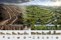
The nine fields of action range from capturing and guiding water, through the development of living soils and vegetation structures, to open storage areas, water treatment, use, maintenance, observation and long-term development. They are structured so that they can be read and applied individually. Their full effect, however, only unfolds in combination. Effective water retention only emerges where measures are not treated in isolation, but conceived and implemented as a connected system.
We want to encourage action. Not every measure has to be large, and not every implementation has to be perfect from the outset. Change often begins with careful observation, a small intervention and the willingness to learn from the place itself. Where water is retained in the landscape, a more resilient landscape emerges step by step:
Land creates water and water creates land.

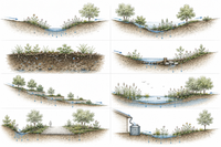
1. Capturing and directing water
At the beginning of every effective water-retention strategy lies a simple but decisive question: How does water enter the system, and what happens in the first minutes after a rainfall event? This early phase is often underestimated. Rain falls onto roofs, paths, farmyards, road edges, slopes or agricultural land, and is often quickly concentrated there. Within a short time, concentrated runoff forms. It can either be used intentionally or cause damage in an uncontrolled way.
The aim of this first field of action is therefore to receive water where it occurs and guide it in an orderly way into a system of retention, infiltration, use or further conveyance. This is not yet about long-term storage in the narrow sense, but about the first step in the water logic: a fast, concentrated problem flow should become an organised inflow into a water-retaining system.
The principle is basically simple. Water is captured, calmed and guided into suitable structures. Examples include directing roof water into swales, cisterns or green spaces; receiving surface water from sealed areas; spring capture where appropriate; and using swales, shallow ditches or above-ground water channels instead of unnecessary piping. Where water carries sediment or enters with high energy, softened inlet points, simple settling and filtering areas and controlled overflows are also needed.
The benefits of such initial interventions are greater than they may seem at first glance. Runoff peaks are reduced, material loss and erosion are diminished, subsequent measures are better supplied, and roof or surface water can be used in a meaningful way. At the same time, not every inflow is harmless. Poorly directed water can cause damage; unstable slopes, polluted inflows or undersized target structures can shift problems rather than solve them. This field of action therefore requires site knowledge, reliable dimensioning and robust, maintainable construction.
Capturing and directing water ultimately means consciously shaping the first contact between water and landscape. Rapid and potentially damaging runoff becomes an ordered component of a water-retaining system. This first step often determines whether water can be kept on site or whether it is lost to the place.
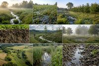
2. Slowing and spreading runoff
Once water has been captured and integrated into a system, the next question arises: How can its flow speed be reduced so that it does not act destructively, but can become effective across the land? In many landscapes, water is discharged very quickly: over steep slopes, sealed surfaces, compacted or bare soils, wheel tracks, paths, ditches or large areas used in a uniform way. Fast-flowing water carries high energy. It removes soil, deepens rills, overloads lower-lying areas and causes local damage and flood peaks. At the same time, this same water is later missing from the soil.
The aim of this field of action is therefore to reduce flow velocity, spread water spatially and thereby reduce erosion, damage and runoff peaks. At its core, it is about three things: slowing speed, lengthening flow paths and bringing water out of concentrated lines back into the area. Concentrated, fast runoff should become a slower, more distributed water flow.
In practice, this can often be achieved with surprisingly simple means. Swales, shallow terrain incisions and vegetated ditches reduce flow energy. Vegetation and soil structure create roughness and slow water down. Sills, small dams, cross structures or terrain steps interrupt flow paths. Small-scale terracing, redirection into adjacent areas and widening of runoff zones help to distribute water spatially instead of forcing it into narrow rills or channels.
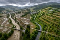
This field of action is also an important component of decentralised flood risk reduction. Many small measures across an area can dampen runoff peaks, delay water flows and relieve streams, canals and settlement areas during heavy rainfall. Flood protection is not created here solely through large technical structures, but through the interaction of many decentralised interventions that take away the destructive energy of water.
For such measures to function over the long term, they must be correctly dimensioned, vegetated and checked after heavy rainfall. Lack of vegetation, inappropriate interventions or insufficient overflows can strongly reduce their effectiveness or create new problems. Slowing and spreading runoff therefore does not mean simply stopping water. It means giving it time and space again. This is precisely where the strength of this field of action lies.
3. Bringing water into the soil
Water only becomes effective for a site when it is not lost as rapid surface runoff, but can enter the soil. This is a central problem in many landscapes. Water may fall onto the land, but it does not sufficiently enter the soil. Sealed and compacted surfaces, silted or crusted soils, phases of bare ground without protective cover, intensive cultivation with weakened soil structure and runoff concentration in wheel tracks or slope lines often prevent rainfall from reaching where it is needed: the root zone.
The aim of this field of action is therefore to bring water into the soil as close as possible to where it falls, so that it can become effective as soil moisture, plant-available water and, where site conditions allow, as a contribution to groundwater recharge. For this, water needs time, open pores, soil life, roots and suitable surfaces. It must first be able to reach the ground, the surface must be able to absorb it, and the soil must retain its infiltration capacity.
In practice, this includes infiltration areas, vegetated humus swales, green islands, permeable surfaces and the reduction of unnecessary sealing. Infiltration trenches, shallow retention and distribution structures, strategic vegetation measures, disconnecting dense surfaces from fast drainage, and small-scale terrain modelling help to bring water into areas that can absorb it.
Where water enters the soil, it is removed from rapid surface runoff. Runoff volumes and runoff peaks decrease, lower-lying areas are relieved, and the erosive force of water is reduced. Soils that can absorb water lose less fine soil, seal over less often and remain more stable over the long term. At the same time, soil moisture in the root zone increases, plants are better supplied and susceptibility to drought stress decreases.
Of course, not every site is equally suitable for infiltration. High groundwater levels, unstable slopes, problematic subsoils, contaminated areas or sensitive protected assets require particular caution. Water should therefore not be made to infiltrate everywhere in a schematic way. This field of action also requires site knowledge, observation and site-specific planning. Bringing water into the soil ultimately means reconnecting rainfall with the most important storage space in the landscape. Where this succeeds, rain does not merely become runoff, but soil moisture, plant supply, erosion protection and a more stable water balance.
4. Building soil as a reservoir
Bringing water into the soil is a decisive step. Whether it can also be retained there depends on the quality of the soil itself. Not every soil is an effective reservoir to the same degree. Structure, humus content, rooting, pore volume and biological activity are decisive. Many water problems are therefore, in reality, soil problems. Where soils are compacted, low in humus, biologically degraded or permanently unprotected, the landscape loses its ability to hold rainfall effectively. Water then infiltrates less easily, is stored less effectively and is available to plants only for a short time.
The aim of this field of action is to develop soil so that it can absorb, store, buffer and gradually release water back to plants and the landscape. A living, well-structured soil enriched with organic matter does not function like a rigid container, but like a living buffer space. Its storage effect is based on the interaction of stable soil structure, organic matter and active soil life, which makes long-term development possible in the first place.
In practice, this means above all building organic matter and keeping it within the system. Mulch, surface composting and humus building are central elements. Equally important is the resulting support of soil life: year-round soil cover, good rooting, reduced soil disturbance and conditions in which earthworms, microorganisms and fungi can remain active. This is complemented by protecting the soil structure itself, for example by avoiding compaction and bare soils.
A well-developed soil is one of the most effective decentralised water reservoirs in the landscape. It buffers dry periods, improves even plant supply, reduces susceptibility to erosion, stabilises soil structure and increases resilience to heavy rainfall and heat. At the same time, less water becomes active as rapid surface runoff, which also dampens runoff peaks. Soil building is therefore not only a question of fertility, but a central element of water retention, drought preparedness, erosion protection and decentralised flood risk reduction.
It should not be overlooked that soil building takes time. A single compost application or one-off measure cannot replace a long-term development process. Rapid effects can only be expected to a limited extent, and incorrect or excessive interventions can set back development processes. Building soil as a reservoir therefore means restoring the function of the most important water reservoir in the landscape: carefully, continuously and with patience. Where soil is alive, rooted, rich in humus and structurally stable, water can not only enter but also remain. This is what makes landscapes more resilient.
5. Developing vegetation as water infrastructure
Vegetation is often perceived primarily as a design or ecological element. For water retention, however, it is much more. Plants protect the soil, influence rainfall interception and evaporation, create root spaces, slow wind, cool surfaces and stabilise transitions between dry and wet areas. Where vegetation is absent, patchy or regularly disturbed, the risk of surface sealing, runoff, erosion, drying out, overheating and the loss of structural diversity and biodiversity increases.
The aim of this field of action is to develop vegetation in such a way that it actively stabilises the water balance, soil, microclimate and landscape structure. Vegetation works on several levels at once. It protects the soil surface from raindrop impact and overheating; improves water uptake through its roots; influences the microclimate through evaporation and shade; and structures the landscape through hedges, woody plants, meadows, wetland vegetation or agroforestry systems. Vegetation is therefore not an addition to water retention, but a supporting part of it.
In practice, this field covers a wide spectrum. At the area level, it includes permanent vegetation cover, extensive meadows, edge habitats and afforestation of erosion-prone land. Structural vegetation is created through hedges, woody strips, groups of trees, riparian and wetland vegetation, near-natural forests and transition zones. In settlement areas, green facades, green roofs, vegetated swales, green islands and shade-giving trees are added.
The effects are diverse. Vegetation protects soil from raindrop impact and drying out, improves water uptake and rooting, reduces susceptibility to erosion, buffers temperature extremes, increases structural diversity and biodiversity, and slows wind and evaporation. During heavy rainfall in particular, it reduces the speed with which water becomes active on surfaces. During dry periods, shade, soil cover and root activity reduce drying out. Vegetation therefore connects water retention, soil protection, drought preparedness and decentralised flood risk reduction in a particularly elegant way.
As with all other measures, this field also requires a sober assessment. Not every vegetation measure automatically has a positive effect. Poorly placed or unsuitable planting can create a range of problems, including conflicts with use. Vegetation also develops dynamically over time. Ecological stages of succession must always be considered in planning and implementation. The more this natural dynamic is understood, allowed and supported, the more stable and successful site-adapted vegetation can become. It is most effective where it is not developed in isolation, but together with soil building, water guidance and land use.
Developing vegetation as water infrastructure means understanding plants not only as greening, but also as active carriers of the water balance within an ecological structure. Where diverse plants protect the soil, take up water, buffer the climate and structure landscapes, vegetation becomes an effective infrastructure for water retention.

6. Strengthening animals and fungi as co-creators
Water retention in the landscape is not only a question of soil, vegetation and construction measures. Animals and fungi also help soils remain receptive, slow the movement of water and make wet areas more stable. These effects are often less immediately visible than a ditch, a swale or a pond. Nevertheless, they are significant for the long-term functionality of many landscapes. Where biological processes are weakened, the landscape loses internal regenerative capacity. Where they are strengthened, more stable and adaptable systems emerge.
The aim of this field of action is to support biological processes and organisms in ways that strengthen soil structure, water storage, wetland areas and ecological stability. Animals and fungi act primarily on three levels. Soil organisms create pores, channels and stable aggregates. Digging, burrowing, mixing and mycelial growth influence how water is stored and conveyed in the soil. Certain animal species can also help shape local water conditions, retention and habitat structure, especially in water bodies and wetland areas.
Typical contributions include earthworms and other soil animals, which promote porosity and aeration and integrate organic matter into soil processes. Fungal mycelium connects organic and mineral material; mycorrhiza supports plants in water and nutrient uptake; and fungi contribute substantially to stabilising soil aggregates and developing living soils. In suitable areas, species such as beavers can locally alter water levels, retention and habitat structures, thereby expanding wet areas and retaining water.
Edge structures, wetland zones and woody areas provide habitats for beneficial organisms, soil organisms and ecological processes that influence water.
The strength of these processes lies less in spectacular single events than in their long-term effect. Where soil life is active, fungi interact with plants and wetland structures are biologically supported, the landscape’s ability to retain water and compensate for disturbance increases. At the same time, soil structure, water uptake, water storage, ecological resilience and biodiversity improve. Animals and fungi are therefore not marginal topics, but part of the internal functioning of water-retaining landscapes.
At the same time, this biological level should neither be overestimated nor romanticised. Biological effects are site-dependent, cannot be forced at will and can also create local conflicts with land use or infrastructure. They need time and suitable conditions. Strengthening animals and fungi as co-creators therefore means understanding water retention not only as a construction or planting task, but also as an ecological one. Where soil organisms, fungi and suitable animal species can become effective, the landscape gains internal stability, storage capacity and regenerative power.
Technical interventions are often not necessary when biological processes are supported and allowed to unfold. This saves resources, time and costs, and is often the better and more sustainable solution.

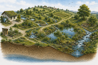
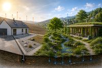
7. Creating open reservoirs and wet landscapes
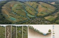
Not all water should disappear into the soil immediately. Effective water retention in the landscape also needs open reservoirs and wetland structures in which water remains visible, tangible and effective over longer periods. These include ponds and pools, wetland zones and marsh areas, floodplains and peatlands, retention areas and cascades, near-natural water bodies and upgraded stream and river sections. Many of these structures have been pushed back, technically altered or have disappeared from landscapes altogether. As a result, important buffering, storage and habitat functions are missing.
The aim of this field of action is to retain water in open storage and wetland areas in such a way that runoff is dampened, residence time is extended, habitats are created and water balances are stabilised across the space. Open reservoirs and wet landscapes work through several functions at once. They retain water, dampen runoff, improve water quality through sediment and nutrient retention, stabilise the microclimate through evaporation and moisture, and create habitats of high ecological value. Open water and wetland areas are therefore not merely reservoirs, but multifunctional landscape elements.
In practice, the spectrum ranges from near-natural ponds and pools to landscape-integrated retention basins, collecting basins, swales and cascades of several smaller reservoirs, wetland zones, shallow-water and treatment areas, rewetted wetland areas and upgraded peatland sites. Added to this are water corridors that are widened, structured, supplemented with side channels or freed from hard technical confinement. Such measures are particularly effective where they are not conceived as isolated objects, but as part of a network of small and medium-sized retention structures.
The benefits are correspondingly diverse. Open reservoirs make water retention visible, contribute to decentralised flood risk reduction, extend water residence times, improve water quality, stabilise the microclimate and promote biodiversity and habitat diversity. At the same time, they enhance water and landscape spaces spatially and atmospherically and can create additional qualities for use and experience.
However, not every site is suitable for open reservoirs. Water levels can fluctuate; material inputs and nutrient loads must be considered; poor siting or implementation can lead to siltation or loss of function; and peatlands or sensitive wetlands require particular professional care. Open reservoirs are therefore not schematic standard solutions. They must be planned for the site, integrated into the water and use system, and accompanied over time. Creating open reservoirs and wet landscapes means making water visible, effective and alive in the landscape again. Where ponds, wetland zones, floodplains, peatlands and near-natural water corridors retain water, not only retention emerges, but a more stable, cooler and ecologically richer landscape and living environment.

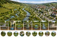
8. Cleaning, using and circulating water
In many settlement and landscape areas, water is quickly discharged after a single use. Rainwater is channelled, treated and removed from the local system. Even slightly polluted water is often lost in this way, although it could still be used on site. This linear use — use and discharge — means that water is locally missing, soils and vegetation receive less supply, microclimatic effects are lost and technical systems are overloaded. A sustainable approach to water therefore requires a change in perspective: water should not disappear as quickly as possible, but remain in the system for as long as possible and be used more than once.
The aim of this field of action is to guide, clean and use water in such a way that it remains effective in the local system for as long as possible and can be used more than once. At its core, this means first making water available, then cleaning or pre-treating it in a site-appropriate way depending on its use and level of pollution, and then circulating it rather than removing it from the system after a single step.
In practice, this begins with collecting and using roof and surface water, for example through cisterns, storage tanks or simple irrigation solutions. Decentralised forms of treatment are added, such as planted soil filters, constructed wetlands, near-natural treatment zones or sedimentation areas. Such systems become particularly effective when storage, use, treatment and subsequent infiltration are linked. In this way, water can become effective more than once for gardens, green spaces, operations, vegetation or microclimatic buffering.
This circular approach is also significant in agriculture. Rainwater from buildings and farmyard surfaces can be used for irrigation or operational purposes. Decentralised reservoirs and collecting basins enable delayed use over time. Wetland zones and retention areas can simultaneously serve as storage, treatment and use areas. Especially in water-scarce periods, better use of available rainfall can noticeably reduce dependence on external water sources.
The benefits of such cycles lie not only in conserving resources. Water remains longer in the local system, the need for external water supply decreases, sewer systems and technical installations are relieved, soil moisture and vegetation benefit, cooling and evaporation effects are improved, and water, soil and material cycles interlock more effectively. This field of action connects technical, ecological and functional aspects of water retention in a particularly tangible way.
Of course, not every solution is useful everywhere. Not every water quality is suitable for every use, hygienic and legal requirements must be observed, and incorrect use can pollute soil or water bodies. Technology that is too complex or oversized is often prone to failure and uneconomical. The aim should therefore be solutions that are as simple, site-appropriate and robust as possible. Cleaning, using and circulating water ultimately means not treating it as a waste product, but keeping it in the system as a valuable resource. Where water is used more than once, the efficiency, stability and resilience of landscapes and settlement areas increase significantly.
9. Securing planning, maintenance and observation
Many water-retention measures are simple, near-natural and robust. Nevertheless, they do not remain effective automatically. Swales silt up, ditches become overgrown, inlets change, vegetation develops differently than expected, and uses change over time. In addition, water behaves dynamically. The effect of a measure often only becomes visible during heavy rainfall, longer dry periods or in interaction with other elements. It is therefore not enough simply to plan and build measures. They must also be understood, accompanied and further developed.
The aim of this field of action is to plan, implement, use and observe water retention in such a way that measures remain functional, adaptable and site-appropriate over the long term. Long-term viable systems are based on a few simple principles: plan for the site, implement robustly and manageably, think about maintenance through use from the outset, observe effects and adjust early if necessary.
In practice, this begins with looking closely. Water pathways and problem areas should be observed before implementation; priorities should be set according to impact and feasibility; and measures should be linked wherever possible. Safe overflows and emergency flow paths must be considered early. Maintenance through use involves checking sediment traps, swales, ditches and overflows, and avoiding unnecessary interventions. Observation includes, for example, checks after heavy rainfall and dry periods.
The benefits of such procedures are clear. Measures remain functional over the long term and follow-up costs decrease. Water retention thereby becomes not a rigid project, but a continuous improvement of land use and landscape dynamics.
Lack of responsibilities, unclear maintenance, overly complex systems or insufficient observation can quickly devalue good measures. Small problems then become large, and a well-intentioned intervention leads to disappointment. Water retention therefore needs not only good ideas, but also organisational reliability. Securing planning, maintenance and observation ultimately means understanding water retention not as a one-off project, but as a permanent development task. Where measures are observed, maintained and adapted, they remain effective — and this is precisely where long-term resilience emerges.
State of the approach / professional context
Water retention in the landscape is not an entirely new topic. Various disciplines have long developed approaches that address water balance, soil development, vegetation, water corridors and landscape functions. Hydrology and water management, soil science and agricultural sciences, landscape planning, ecology, restoration, forestry, land-use systems and urban water management each describe aspects of this relationship in detail. In practice, however, these aspects are often treated separately.
The approach presented here therefore understands water retention as a connecting principle between these disciplines. The focus is not on a single measure, but on the interaction of water guidance, soil development, vegetation, biological processes, land use and spatial design. The approach is therefore systemic and integrative. It combines technical, ecological and use-related perspectives into a shared framework for action.
In terms of content, it is closely connected to various established concepts: nature-based water management and decentralised retention, European Natural Water Retention Measures, sponge-city principles, soil protection and humus building, agroecological management approaches, and the restoration of water bodies and wetlands. Its particular strength does not lie in inventing individual new measures, but in bringing existing knowledge together into a clearly structured and practically applicable framework. The practical development of decentralised water retention was also strongly influenced by the work of P. A. Yeomans and Brad Lancaster. In “Water for Every Farm”, Yeomans presented a visionary approach, strongly based on topography and landscape, in which water guidance, reading the terrain and land use are brought together systemically. Brad Lancaster translated these basic ideas into a very clear, practical and broadly applicable form with his publication series “Rainwater Harvesting for Drylands and Beyond”.
A substantial part of the landscape is used for agriculture. Agriculture therefore plays a central role in water retention. From a professional perspective, it is well established that soil structure, humus content, rooting, management practices and material inputs have a decisive influence on water uptake, storage and runoff behaviour. The approach presented here therefore understands agriculture not only as a problem field, but also as a decisive field of design and action.
Characteristic of this approach are its consistent orientation towards decentralised solutions across the land; the connection between water, soil, vegetation and use; the combination of small and medium-sized measures instead of a few large structures; a strong focus on practicality and implementability; and the emphasis on observation, maintenance and long-term development. The approach therefore remains deliberately compatible with existing planning and management systems and can be integrated step by step.
In the context of climate change, water retention is gaining additional importance. More frequent heavy rainfall events, longer dry periods, rising temperatures and increasing pressures on soils and water bodies require solutions that do not treat flood protection, drought preparedness, soil protection, biodiversity and microclimatic stabilisation separately, but think them together. This is precisely where the strength of decentralised water retention lies.
At the same time, this approach does not replace detailed professional planning in complex or sensitive areas. It provides orientation and practical guidelines, but must always be applied in a site-specific way. Its greatest strength unfolds across the land, in the interaction of many measures and in long-term development. Decentralised water retention is therefore not a new single instrument, but a connecting approach that bundles existing professional knowledge and translates it into a practical framework for action.
Sources and literature
The following selection contains key professional foundations and further literature on water retention in the landscape. It connects scientific knowledge with practice-oriented approaches from German-speaking countries, the European context and selected international foundations. In addition to institutional professional sources, several key publications are important because they have strongly shaped the approach presented here in terms of content and method.
For German-speaking countries, professional foundations on water management, climate adaptation, flood-risk management, soil protection, erosion control and sustainable agriculture are particularly relevant. These include publications and professional reports from the Austrian Environment Agency, the German Environment Agency, the Austrian Federal Ministry of Agriculture, Forestry, Regions and Water Management, the Bavarian State Research Center for Agriculture and the Bavarian Environment Agency. For soil science, forestry and agricultural questions, publications from the Austrian Research Centre for Forests, the University of Natural Resources and Life Sciences Vienna, KTBL and FiBL are also significant.
Particularly important practice-shaping key references are P. A. Yeomans, “Water for Every Farm: A Practical Irrigation Plan for Every Australian Property” (first published in 1954; later editions), and Brad Lancaster, “Rainwater Harvesting for Drylands and Beyond”, especially volumes 1 and 2. Yeomans connects topography, water guidance, soil fertility and land use in an exceptional way. Lancaster translates the principles of rainwater harvesting into a very clear, application-oriented language and shows through numerous examples how water can be meaningfully collected, guided, stored and used in settlement and landscape spaces.
In the European context, the Natural Water Retention Measures of the European Commission are particularly relevant, as are publications by the European Environment Agency on nature-based solutions, the EU Soil Strategy for 2030, measures of the Common Agricultural Policy relating to soil and water, and analyses by the Joint Research Centre on soil erosion, organic soil carbon and land use. Important international and scientific foundations include the work of Rattan Lal on soil function and water-holding capacity, David R. Montgomery on soil erosion, and Johan Rockström on green water and blue water. Additional relevant foundations include the IPCC Special Report “Climate Change and Land”, FAO publications on water and sustainable agriculture, UNEP guidance on nature-based solutions for water, and international foundations on wetlands and water-related landscape development, for example by Wetlands International or The Nature Conservancy.
For practical work on site, what matters less is the completeness of a bibliography than the ability to translate the basic principles from these professional contexts into a site-specific approach. This summary should therefore not be understood as a comprehensive scientific review, but as a practice-oriented approach that builds on professionally robust foundations and makes them applicable.
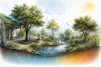
Note: The graphics shown above were created with the support of AI — ChatGPT 5.5 — in May 2026.